


 |
| After eruption 2010 |
Said the people, the morning is the best time to enjoy the viewbefore the mist-shrouded Mount Merapi. So at 07.00 am we wereoff to Kaliadem, a cool area at the foot of Mount Merapi, about 25km north of Yogyakarta. We chose an alternative route throughMaguwo because that path has more fields than through RoadGround. Sure enough, just a few kilometers away from the city, the landscape green fields directly feast for the eyes, like the paintingsMooi Indie. Cool air was immediately ambushed a car through a window left open. Faintly smell the rice stem; it smells fresh, like the smell of grass after rain washed.
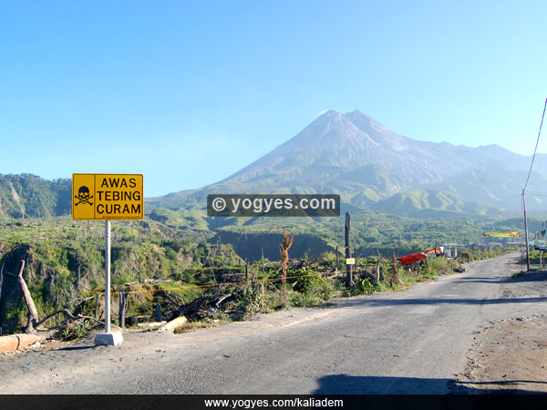
The sun not yet high when we arrived at Kaliadem, some localsseemed to be getting ready to find grass for their cattle. Althoughthere is a thin fog, Mount Merapi is seen intact as expected.Towering up to 2980 meters above sea level, the mountain really looks dashing. His back looks glittery overwritten morning sun,while a thin smoke peak. Ladies and gentlemen, this is one of the most active volcanoes in Indonesia!
Behind her looking so calm, Mount Merapi save tremendous forces of nature. Some scientists suspect a large eruption of Mount Merapi is the cause of the ancient Mataram kingdom moved to East Java in the 10th century. When it erupts, capable of spitting out clouds of Mount Merapi hot (800-1000 degrees Celsius) that slides down with a speed of up to 70 km / hour. In 1930, clouds of heat from the eruption of Mount Merapi forest burned, 13 villages, and 1400 residents in an instant.
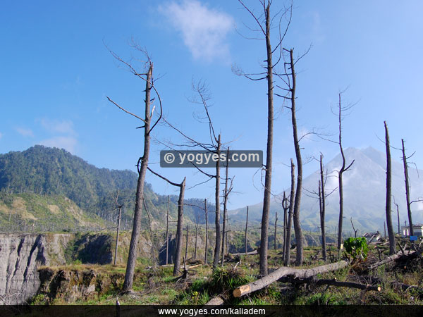
The last eruption of Mount Merapi occurred in 2006. Millions of cubic volcanic material spilled at Kali Kali Gendol and Krasak, the remaining fraction Kaliadem crashing and leaving a trail that we can still see. Kaliadem which was once a pine forest is now buried in sand, rocks and other volcanic material. In the east the ruins of shops that seemed buried volcanic material up to half the building.In the west there is a protective bunker which ironically is also buried in volcanic material as thick as 3 feet. The eruption of Mount Merapi in 2006 was also killed two people sheltering in the bunker.It took weeks after the eruption of volcanic material before the hoards of Kaliadem it cools and the region can be visited again. after 4 years on Mount Merapi erupted again on October 26, 2010, the power of larger eruptions than in 2006, the eruption of 2010 and then destroy Kaliadem sights and killed hundreds of people, including caretaker Mbah Maridjan Mount Merapi.
But like other natural show of strength, the eruption of Mount Merapi, also has a good side. Volcanic ash from Mount Merapi to give fertility to the soil at the foot of the mountains and thousands of hectares of rice fields below. Millions of cubic sand spit also has to support hundreds of local residents who make a living by mining the sand. Four years after the eruption, the area was green and cool Kaliadem again. Pine trees that once burned, now have started to grow. Kaliadem now become a tourist place to enjoy the natural beauty of Mount Merapi, as well as witnessing proof that nature has its own equilibrium.


0 komentar:
Posting Komentar